Whazzup?” Those were the first words that greeted me as I pulled up to Hide-Away Cabins & Inn at Possum Kingdom Lake, west of Fort Worth. The man wearing board shorts and flip-flops was loading a cooler into the back of his truck. I gave him a nod and headed to my room. I knew that Possum Kingdom attracted colorful characters and spring break parties, but I was there to find my own peace on the water and perhaps a semblance of the original Possum Kingdom.
The Morris Sheppard Dam began filling the area’s stark and dramatic limestone canyons with water in 1941. The project was designed to alleviate flooding on the temperamental Brazos River and provide hydroelectricity for a growing state. Recreation was low on the list of benefits of Possum Kingdom when it was on the drawing board.
Those priorities changed in 2007 when hydroelectric generation stopped. “The infrastructure was aging, and we were going to have to do major upgrades,” explains Judy Pierce, public information officer for the Brazos River Authority, which manages the lake. Now the dam is more about flood control and the water supply it holds. Besides, the area’s No. 1 economic engine is now recreation on the water.
“We call this the ‘Great Lake of Texas’,” says Gayla Chambers, executive director of the Possum Kingdom Chamber of Commerce. PK, as the locals call it, boasts close to 20,000 acres of water and more than 300 miles of shoreline. Even though PK isn’t among the Texas top five for size, it’s a much-loved waterway for the people of the Dallas-Fort Worth region and West Texas. The area around the lake touches Palo Pinto, Stephens and Young counties and is serviced by United Cooperative Services, and Comanche, Fort Belknap and Tri-County electric cooperatives.
“There are no hard numbers, but we estimate there are 1,500 full-time residents,” Chambers says. PK remains unincorporated, and residents are scattered along the long shoreline, so there is no exact population number. During the peak season, from May through September, Chambers estimates that as many as 3 million people visit the lake, staying in cabins, fishing camps, vacation homes and a few high-end resorts. “People come for a weekend and then end up buying a house,” she says.
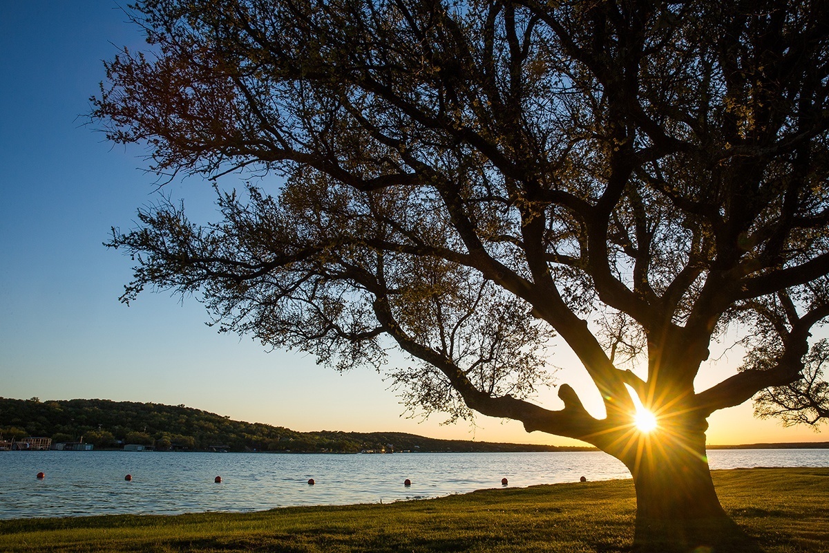
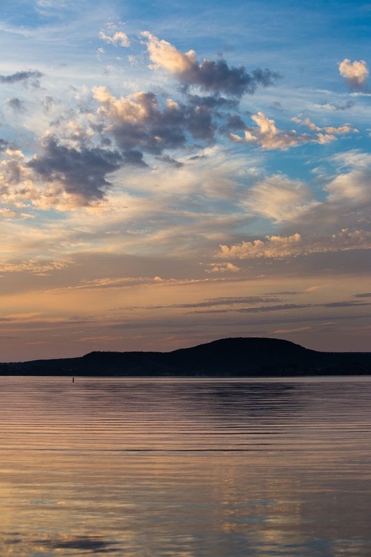
As I considered my plans to learn more about the history of the Brazos River and the lake it created, I watched the afternoon sun set over the water from the peninsula on the east side of the lake where FM 2951 juts west. The sky came alive with pinks, oranges and a deep purple before washing to black. In the parking lot near my weekend rental, trucks and lively voices came and went, but the 11 p.m. noise curfew held, and I set an early alarm.
I knew that in this area, 80 miles west of Fort Worth, the tributaries that the Spanish dubbed Los Brazos de Dios, “the arms of God,” flow southeast from the rolling plains through the Cross Timbers and combine to power the Brazos River toward the Gulf of Mexico. Salt deposits from the aptly named Salt Fork of the Brazos (where the saline content can be twice that of seawater) render the Brazos mostly unsuitable for human consumption. Despite that, the area has been continuously inhabited for millennia. Traces of one of North America’s earliest human cultures, known as the Clovis people, have been found along a tributary of the Brazos in New Mexico.
Certainly, native people roamed the Brazos basin long before the Spanish and French arrived. When Anglo settlers began moving to the area in the 1800s, a new name arose from a fur trader whose best pelt suppliers he dubbed “the boys from Possum Kingdom.” The name stuck.
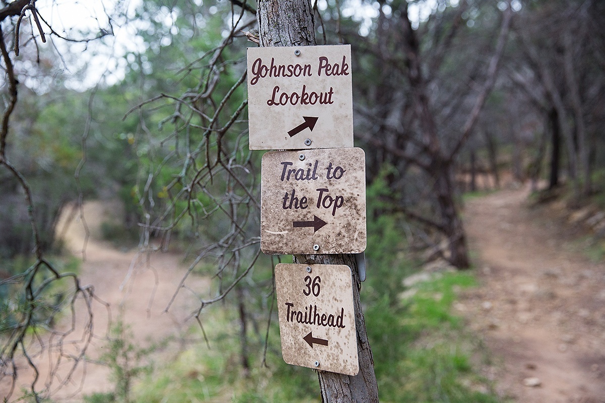
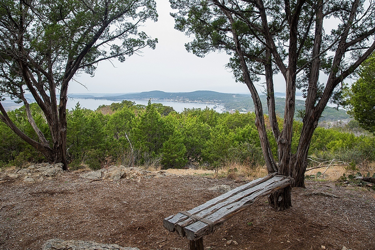
The morning broke cool and cloudy. I loaded the dog into the car, filled a canteen and drove a mile to the South D&D trailhead, one of many access points for a new 16-mile hike-and-bike trail, also managed by the Brazos River Authority. My goal: Johnson’s Peak, a high point offering a 360-degree view.
The peak is named for J.A. Johnson, who moved to the area in the 1880s and, according to legend, hiked to the peak with a Comanche leader who asked him to care for the land the way his people had. Years later, when Johnson sold the land to Eugene Constantin, he reportedly took Constantin to the same peak and delivered the same speech about stewardship.
“As the story goes” is a common phrase in Possum Kingdom. The area is rife with stories tied to geologic features and conflicts between Anglo settlers and local tribes.
I learned from David La Vere’s book The Texas Indians (Texas A&M University Press, 2004) that settlers first came to the area in the 1830s and lived in relative peace with remnants of the Delaware, Shawnee, Tonkawa, Wichita and Caddo tribes. Once frontier settlements were established, the agricultural tribes were pushed off their fields, and hunting tribes saw the decline of the buffalo. Comanche, Apache and Kiowa tribes began raiding. By 1859, a commission authorized by Texas Gov. Hardin Runnels recommended that all tribes be relocated to reservations in Oklahoma.
“This county [Palo Pinto] was one of the worst for Indian attacks,” explains Possum Kingdom historian Kevin VanDuser in his history of the area, Possum Kingdom Journal. VanDuser was an 11-year-old Tenderfoot Boy Scout when he first came to the area for summer camp. “I was a kid armed with a notebook and a Kodak camera, and history is what interested me.”
VanDuser visited Native American sites via canoe and listened to local ranchers and anyone else with a story to tell. He continues to stitch together bits and pieces of local lore today.
I read the plaques offering stories of settlers and natives, many written by VanDuser, a member of United Cooperative Services.
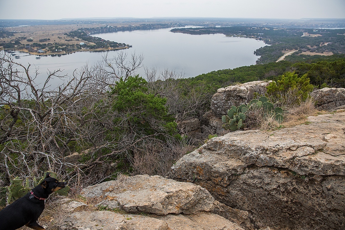
Today, the well-maintained hiking trail full of switchbacks is shaded by cedar and oak and punctuated by benches and scenic overlooks. Huge rocks line the path to the pinnacle, where the view opens up. I scan the route of the Brazos channel through the bends and turns of the lakefront, now peppered by vacation homes and docks.
Looking south, I can make out the iconic Hell’s Gate formation. The peninsula that stretches before me serves as a summer camp for the Boy Scouts and the YMCA, and the hike-and-bike trail shares land with the habitat of the endangered golden-cheeked warbler.
Looking north, I see the site of the submerged ghost town of Pickwick. First settled in the 1850s, the town grew slowly. After a disastrous cotton crop in 1915, the small population dwindled. The Brazos River Authority bought the remaining properties as part of the Morris Dam project, and lake water submerged the town in 1941. Building remnants, including chimneys, appear when the lake level drops.
I finish the 5-mile loop as I descend from the peak. I drain my water bottle and thankfully note the cooler temperature. As midday approaches, the buzz of boat traffic picks up on the water below.
“The only way to see the beauty of PK is from the water,” Chambers says, so I head to the lakefront, where WaterRush watercraft rentals owner Jesse Swanson says traffic on the water is a constant in summer months. “It used to be mostly speedboats, but we’re seeing more pontoons,” Swanson explains. Water skiing has waned as more wakeboards and tubers enjoy the long summer afternoons. Then there’s the newest in lakeside entertainment, the Jetovator, a kind of hydropowered pogo stick that can launch a person 25 feet into the air.
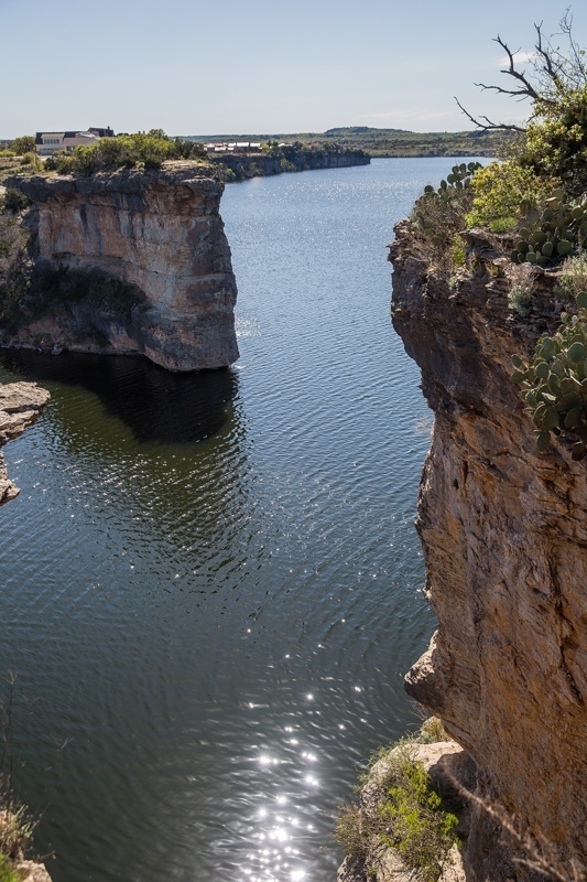
I pass on the water rocket and decide on a traditional kayak. I load the pup on board and paddle a few miles (20 minutes by Jet Ski or speedboat) to Hell’s Gate, the iconic limestone gateway for which PK is known. The cliffs are more than 80 feet tall at the waterline, with water depths greater than 16 feet, making for impressive photos and a perfect platform for professional cliff divers who flock here for a competition each summer.
Six miles around the bends of the lake, just below Morris Dam, a completely different experience awaits. It is the gem of the Brazos, as John Graves recorded in his famous book, Goodbye to a River (Random House, 1960). In 1957, Graves and a 6-month-old dachshund piloted a canoe down the Brazos between the newly erected Morris Dam and Lake Whitney. Engineers had proposed as many as 13 dams for that stretch of the river, and Graves thought this was his last chance to experience the river of his youth. The winding narrative layers lyrical observations of the natural and spiritual journey with local history of settlers and natives. It’s a journey of environmental conservation, history and personal reflection, perhaps best characterized as a Texas version of Henry David Thoreau’s Walden. This stretch of the Brazos is now known as the John Graves Scenic Riverway and draws anglers and paddlers from all points of the compass.
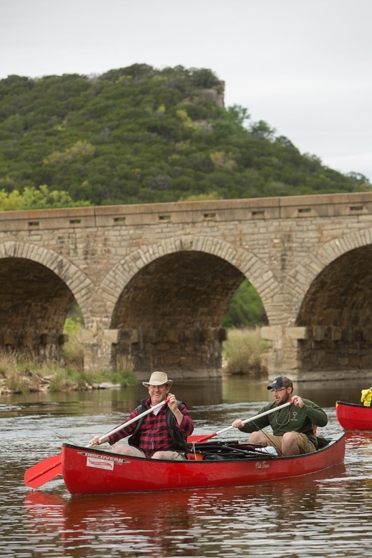
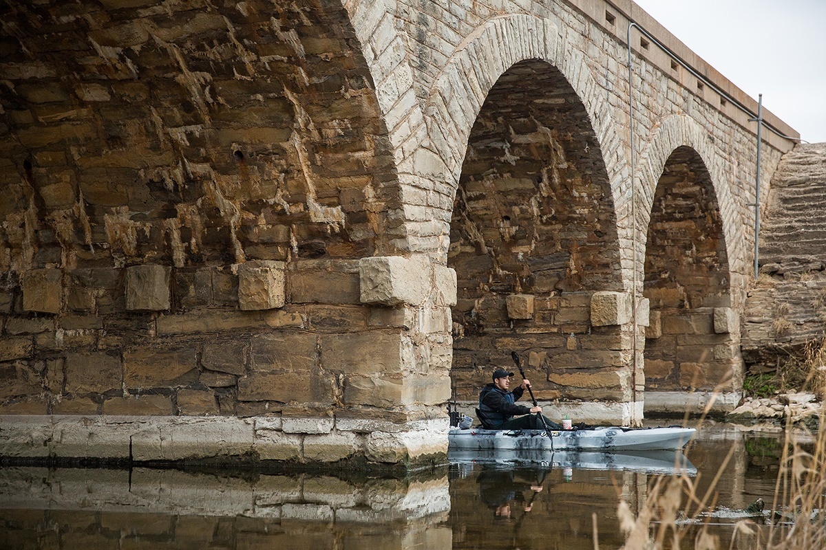
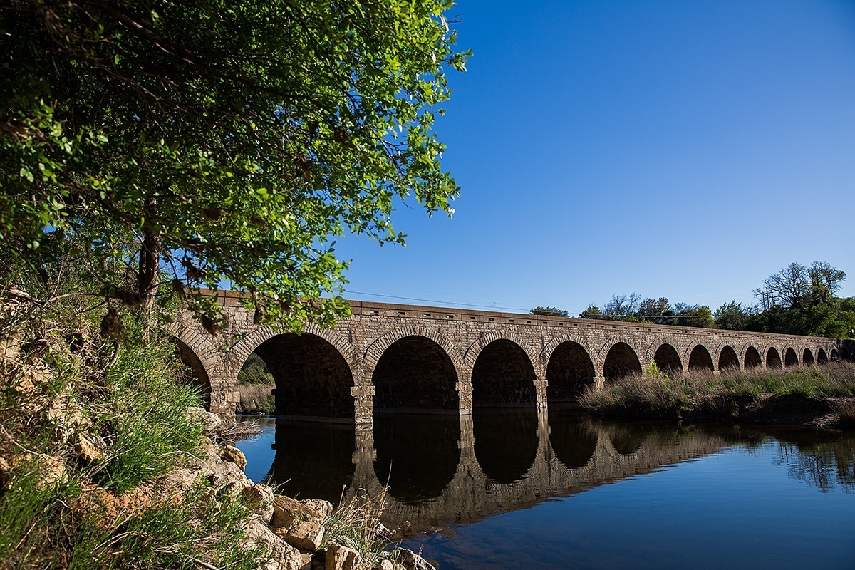
A short drive away, near the point where the Brazos River flows out of Morris Dam, I find the Possum Kingdom Stone Arch Bridge, the longest masonry arch bridge in Texas, built by the Works Projects Administration in 1942.
On this lazy weekend afternoon, I find a half-dozen anglers and their families casting from the banks around the bridge. A few kayaks and canoes drift on the river and under one of the 18 arches of the bridge. The Brazos River Authority has created a hiking trail that winds along the river bluffs just beneath the dam, and from here, looking downstream, it is possible to imagine life on the Brazos before the lake.
The pup finds a deer path and bounds through the dry reeds for a cool dip in the river. She scares a few ducks into the air, and they flap, perturbed, downstream to land again on calm waters. From here the quiet is deafening. No buzz of speedboats or roar of floodgates, just the slow heartbeat of the Brazos. Am I now in the original Possum Kingdom?
——————–
Julia Robinson is an Austin photojournalist.